Email Password remember me in this computer

This website is better viewed with
FIREFOX
or GOOGLE CHROME
Review www.t-globe.com on alexa.com

Provinces and Regions of Thailand


Destination: ThaiInfo

Welcome to Amazing Thailand

Total Page Views for ThaiInfo: 2,912,855 - Views this week: 2,912,855
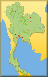
The 5 administrative Regions
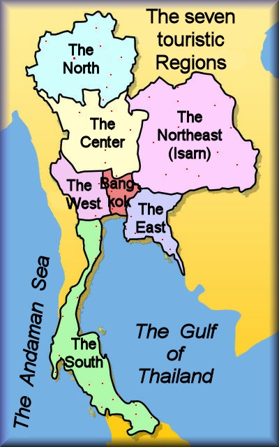
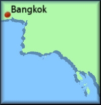
The 7 touristic Regions  
The administration of Thailand divides Thailand into 5 Regions where the capital of Bangkok belongs to the Central Region


--The mountainous North


-- The historic Center
-- The Northeast (Isarn)
-- Greater Bangkok
-- The West
-- The East Coast


-- The South beginning with Phetchaburi
For touristic descriptions we divide Thailand into 7 Regions which derive from their geography and their historic past

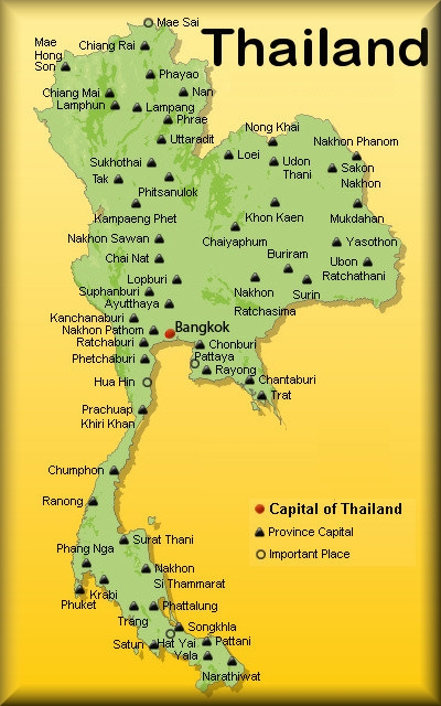
The 77 Provinces of Thailand
Thailand has 77 provinces (Changwat), of which about 53 are of major interest to foreign tourists. Among these are all 9 provinces of the North and all 16 provinces in the South. 
All provinces have the same name as the provincial capital which is called Amphoe Mueang to distinguish them.

Each province is subdivided into 4 to 32 districts (Amphoe), totaling 878 districts in all of Thailand. In addition there are 50 districts of Bangkok, which are called Khet. 

A district consists of several towns (Tambon), consisting of villages (Mu Ban). A single village is called Ban. The village remains the social home of each Thai person, even if he works in the distance. 

In the near future: 
We shall present touristic attractions in all 77 provinces of Thailand 
During the next 2 years the t-Globe-Team will endeavour to discover even the most subtle tourist attractions in the less traveled provinces and will be happy to present them on this website. 
A successful start has been made with our high-class t-Globe Thailand Travel Magazine, whose first editions are presented on the website www.issuu.com/tglobe  in English and Thai language to be read online and printed out on your printer, if you like.

List of the 77 Provinces (in the 7 touristic Regions)
The 9 Provinces in the North

-- Chiang Mai (เชียงใหม่)
-- Chiang Rai (เชียงราย)
-- Lampang (ลำปาง)
-- Lamphun (ลำพูน)
-- Mae Hong Son (แม่ฮ่องสอน)
-- Nan (น่าน)
-- Phayao (พะเยา)
-- Phrae (แพร่)
-- Uttaradit (อุตรดิตถ์)
 

+- 20,107 sq.km.     1,666,000 inhabitants
+- 11,678 sq.km.     1,229,000 inhabitants
+- 12,534 sq.km.        768,000 inhabitants
+-   4,505 sq.km.        406,000 inhabitants
+- 12,681 sq.km.        249,000 inhabitants
+- 11,472 sq.km.        476,000 inhabitants
+-   6,335 sq.km.        487,000 inhabitants
+-   6,538 sq.km.        463,000 inhabitants
+-   7,838 sq.km.        464,000 inhabitants
The 14 Provinces in the Center

-- Ang Thong (อ่างทอง)
-- Ayutthaya (พระนครศรีอยุธยา)
-- Chai Nat (ชัยนาท)
-- Kamphaeng Phet (กำแพงเพชร)
-- Lop Buri (ลพบุรี)
-- Nakhon Sawan (นครสวรรค)
-- Phetchabun (เพชรบูรณ์)
-- Phichit (พิจิตร)
-- Phitsanulok (พิษณุโลก)
-- Saraburi (สระบุรี)
-- Sing Buri (สิงห์บุรี)
-- Sukhothai (สุโขทัย)
-- Tak (ตาก)
-- Uthai Thani (อุทัยธานี)
 

+-      968 sq.km.        285,000 inhabitants
+-   2,557 sq.km.        769,000 inhabitants
+-   2,469 sq.km.        335,000 inhabitants
+-   8,607 sq.km.        725,000 inhabitants
+-   6,199 sq.km.        753,000 inhabitants
+-   9,597 sq.km.     1,074,000 inhabitants
+- 12,668 sq.km.        996,000 inhabitants
+-   4,531 sq.km.        553,000 inhabitants
+- 10,815 sq.km.        843,000 inhabitants
+-   3,577 sq.km.        609,000 inhabitants
+-      823 sq.km.        216,000 inhabitants
+-   6,596 sq.km.        603,000 inhabitants
+- 16,406 sq.km.        540,000 inhabitants
+-   6,730 sq.km.        327,000 inhabitants
The 20 Provinces of Isarn

-- Amnat Charoen (อำนาจเจริญ)
-- Bueng Kan (บึงกาฬ)
-- Buriram (บุรีรัมย์)
-- Chaiyaphum (ชัยภูมิ)
-- Kalasin (กาฬสินธุ์)
-- Khon Kaen (ขอนแก่น)
-- Loei (เลย)
-- Maha Sarakham (มหาสารคาม)
-- Mukdahan (มุกดาหาร)
-- Nakhon Phanom (นครพนม)
-- Nakhon Ratchasima (นครราชสีมา)
-- Nong Bua Lamphu (หนองบัวลำภู)
-- Nong Khai (หนองคาย)
-- Roi Et (ร้อยเอ็ด)
-- Sakon Nakhon (สกลนคร)
-- Si Sa Ket (ศรีสะเกษ)
-- Surin (สุรินทร์)
-- Ubon Ratchathani (อุบลราชธานี)
-- Udon Thani (อุดรธานี)
-- Yasothon (ยโสธร)
 

+-   3,161 sq.km.        369,000 inhabitants
+-   4,305 sq.km.        403,000 inhabitants
+- 10,322 sq.km.    1,521,000 inhabitants
+- 12,778 sq.km.    1,123,000 inhabitants
+-   6,947 sq.km.        979,000 inhabitants
+- 10,886 sq.km.     1,733,000 inhabitants
+- 11,425 sq.km.        619,000 inhabitants
+-   5,292 sq.km.        937,000 inhabitants
+-   4,340 sq.km.        337,000 inhabitants
+-   5,513 sq.km.        698,000 inhabitants 
+- 20,494 sq.km.    2,565,000 inhabitants
+-   3,859 sq.km.        500,000 inhabitants
+-   7,332 sq.km.        905,000 inhabitants
+-   8,299 sq.km.    1,307,000 inhabitants
+-   9,606 sq.km.    1,116,000 inhabitants
+-   8,840 sq.km.    1,406,000 inhabitants
+-   8,124 sq.km.    1,376,000 inhabitants
+- 15,745 sq.km.    1,804,000 inhabitants
+- 11,730 sq.km.    1,467,000 inhabitants
+-   4,162 sq.km.       539,000 inhabitants

The 5 Provinces of Greater Bangkok

-- Bangkok (กรุงเทพมหานคร)      
-- Nakhon Nayok (นครนายก)
-- Nonthaburi (นนทบุรี)
-- Pathum Thani (ปทุมธานี)
-- Samut Prakan (สมุทรปราการ)
 

+-   1569 sq.km.    9.000,000 inhabitants
+-   2,122 sq.km.        251,000 inhabitants
+-      622 sq.km.     1,055,000 inhabitants
+-   1,526 sq.km.        933,000 inhabitants
+-   1,004 sq.km.     1,149,000 inhabitants
The 6 Provinces of the West

-- Kanchanaburi (กาญจนบุรี)
-- Nakhon Pathom (นครปฐม)
-- Ratchaburi (ราชบุรี)
-- Samut Sakhon (สมุทรสาคร)
-- Samut Songkhram (สมุทรสงคราม)
-- Suphan Buri (สุพรรณบุรี)
 

+- 19,483 sq.km.        849,000 inhabitants
+-   2,168 sq.km.        845,000 inhabitants
+-   5,197 sq.km.        838,000 inhabitants
+-      872 sq.km.        480,000 inhabitants
+-      417 sq.km.        194,000 inhabitants
+-   5,358 sq.km.        844,000 inhabitants
The 7 Provinces of the East

-- Chachoengsao (ฉะเชิงเทรา)
-- Chantaburi (จันทบุรี)
-- Chonburi (ชลบุรี)
-- Prachinburi (ปราจีนบุรี)
-- Rayong (ระยอง)
-- Sa Kaeo (สระแก้ว)
-- Trat (ตราด)


+-   5,351 sq.km.        666,000 inhabitants
+-   6,338 sq.km.        509,000 inhabitants
+-   4,363 sq.km.     1,268,000 inhabitants
+-   4,762 sq.km.        460,000 inhabitants
+-   3,552 sq.km.        600,000 inhabitants
+-   7,195 sq.km.        542,000 inhabitants
+-  2,819 sq.km.         224,000 inhabitants
The 16 Provinces of the South

-- Chumphon (ชุมพร)
-- Krabi (กระบี่)
-- Nakhon Si Thammarat (นครศรีธรรมราช)
-- Narathiwat (นราธิวาส)
-- Pattani (ปัตตานี)
-- Phang Nga (พังงา)
-- Phattalung (พัทลุง)
-- Phetchaburi (เพชรบุรี)
-- Phuket (ภูเก็ต)
-- Prachuap Khiri Khan (ประจวบคีรีขันธ์)
-- Ranong (ระนอง)
-- Satun (สตูล)
-- Songkhla (สงขลา)
-- Surat Thani (สุราษฎร์ธานี)
-- Trang (ตรัง)
-- Yala (ยะลา)


+-   6,009 sq.km.        487,000 inhabitants
+-   4,709 sq.km.        420,000 inhabitants
+-   9,943 sq.km.     1,520,000 inhabitants
+-   4,475 sq.km.        721,000 inhabitants
+-   1,940 sq.km.        643,000 inhabitants
+-   4,170 sq.km.        251,000 inhabitants
+-   3,425 sq.km.        505,000 inhabitants
+-   6,225 sq.km.        459,000 inhabitants
+-     543 sq.km.         328,000 inhabitants
+-   6,368 sq.km.        508,000 inhabitants
+-   3,298 sq.km.        160,000 inhabitants
+-   2,479 sq.km.        289,000 inhabitants
+-   7,394 sq.km.     1,331,000 inhabitants
+-  12,892 sq.km.       985,000 inhabitants
+-   4,918 sq.km.        615,000 inhabitants
+-   4,521 sq.km.        476,000 inhabitants
New to t-Globe?
Register for free to get the full power of this web site!
Name
Email
Password
Confirm Password

Registered members will be able to:
  • use our Interactive t-Maps
  • see Business Neighborhoods
  • print a customized PDF Guidebook
  • get discount coupons for hotels, restaurants and other services
  • take notes and save them for future use
  • keep track of visited pages